Spring X-Ctry Skiing!
I took advantage of a glorious blue-sky day to go cross-country skiing in the Horseshoe Lake – Bog River area. It’s officially spring, but it still feels like winter with our deep snow-cover.
Bog River Falls
I stopped to view the Bog River Falls on my drive in. This scenic location is just over a half-mile in along Route 421. There is a lovely stone bridge over the Bog River where it empties into Tupper Lake. The falls can be viewed from the bridge or from the parking and picnic areas. The ice and snow are finally beginning to melt.


Horseshoe Lake
After leaving Bog River Falls, it is about a 4-mile drive before you start to see Horseshoe Lake. I stopped at an open area to view the frozen lake. Silver Lake Mountain is in the background.

Route 421 is plowed to an area just before the pavement ends and a dirt road continues. For skiers and snowmobilers, this is the winter parking area. It is located approximately 5.5 miles after turning onto Route 421 from Route 30. There is a wheelchair accessible viewing deck along Horseshoe Lake at the parking spot.

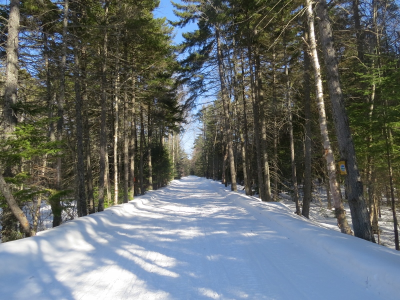
The Ski
The dirt road is groomed for many miles - all the way to Massawepie. (There are future plans for a parking area on the Massawepie end, so a thru-ski with vehicles located at either end will be possible.) Other than my vehicle, there was only one other, with a snowmobile trailer attached.

Since the temperature was around the freezing mark, I used an old pair of wax-less skis, which worked perfectly. The snow conditions were fantastic and I zoomed along!
Shortly after starting, the intersection with the road to the Lower Dam is encountered (the canoe put-in outside of winter). It had a well-worn snowmobile trail and I was tempted to ski the ¾ mile route to the dam, but decided to continue straight on the groomed route.


I passed one of the Horseshoe Lake outlets with a spillway.

There were River Otter, Coyote, and Snowshoe Hare tracks in the snow at this location.
Continuing on this level route, skiers reach the railroad bed after about a mile. The railroad bed is groomed for snowmobiles and there was no sign of the rails. With so much snow, it appeared to be a wide, groomed road. In the middle of such a vast wilderness, it is always interesting to find business advertisements!

The railroad bed looked tempting to ski, and I decided I would try it on my way back. For now, I continued on the groomed road. After another mile, a “Y” intersection is reached. The gated left side is the Low’s Ridge – Upper Dam Trail. It too, had a well-worn snowmobile trail.

At the intersection, I ran into Dawn Andrews who was also out skiing. Dawn is the assistant forest ranger in the Bog River - Hitchins Pond – Low’s Lake area during the summer. We enjoy sharing wildlife sightings whenever we meet.
Dawn skied back toward Sabattis Station taking advantage of the packed-down snowmobile trail on the Low’s Ridge – Upper Dam Trail. I decided to continue on the groomed dirt road toward the right. After a half mile, I turned around and headed back.
The Railroad Bed
At the railroad bed, I skied south, knowing there are bog pockets and boreal habitat nearby.

At the first bog, a Gray Jay imitated a Northern Goshawk vocalization. Gray Jays are currently nesting, and I suspect this bird had a nest nearby and wanted to frighten me away.


It was a quiet weekday, with no sign of any snowmobiles, so I kept skiing all the way to the railroad trestle bridge over the Bog River. If you canoe or kayak on the Bog River to Hitchins Pond, you pass under this bridge. I was surprised to find some open water at this location.


Low’s Ridge loomed large to the southwest.

Bird life encountered included: Hairy Woodpecker, Pileated Woodpecker, Gray Jay, Common Raven, Black-capped Chickadee, Red-breasted Nuthatch, Brown Creeper, Golden-crowned Kinglet, and Common Redpoll. It is hard to believe that in only two to three weeks, this area will begin to fill with returning migrants.
Heading Out
I skied back to the groomed dirt road and the last mile toward my car. At the Horseshoe Lake outlet I noticed a snow-covered beaver lodge.

Just before reaching my car, I heard snowmobiles. Two men slowed way down and waved as they passed by me on their way to the other vehicle in the parking area. I caught up with them as they were loading their machines into the trailer. They had huge smiles, and gushed about what a terrific day it had been! I agreed!

The total ski mileage for this outing was 8 miles. I skied 5 miles round-trip on the groomed dirt road, and 3 miles round-trip on the railroad bed. The route is completely level. Skiers can choose to do a shorter or longer ski outing – and it’s all groomed!

If you plan to visit, there are nice lodging and restaurant options nearby.