Spring into Spring on these peak treks
Spring break is right around the corner and so is the time to say goodbye to winter and welcome in mud season. Of course, this year, for the most part, I don’t see the mud season being a long drawn-out affair — mainly due to the fact we don’t have much snow to melt and the ground should be able to stay ahead of it.
With the spring thaw comes the typical DEC request and recommendation to stay off the High Peaks and seek out other adventures in the low lands — like a hike to a pond, or a smaller mountain. The Tupper Lake Region offers great opportunities to hit the Adirondack trails and enjoy all the activities the warmer weather has to offer.
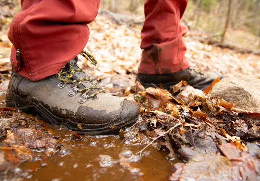
There's no reason to avoid outdoor activities in the shoulder season! Here are a few reminders/tips to keep in mind during spring hiking: Hikers should note that tromping through mud causes irreversible erosion damage, widens trails, and kills vegetation. Also, roads that are un-maintained often become what appears to be driveable. This is not always the case and while gates are often closed, some do not have gates. Using these roads can cause serious rutting, and even get your vehicle stuck — for example the roads though Massawepie and back to Horseshoe Lake should be avoided until they have hardened.
So, to help you plan your spring break adventure, here is a list of five destinations to choose from in the Tupper Lake Region. They range in length, and are open and ready for you to enjoy - remember to bring your camera!

St. Regis Mountain
Where’s that? Follow Route 3/30 toward Saranac Lake. Once Route 3 and Route 30 split, take a left and follow Route 30 into Paul Smiths. Take the first left after Paul Smith's College onto Keese Mill Road and continue for just under 3 miles to the trailhead parking on the left.
The actual trailhead is just a short distance further up the dirt road; there is no parking up along the dirt road. This 3.4 mile trail will gain you ample elevation as you climb to over 2800’ and arrive at a historic fire tower peak. While the fire tower is not yet open to the public, a not-for-profit group is working on a remedy for that as we speak. The trail is mostly a gentle climb but a few areas will gain you some serious elevation. Atop the final steep section the trail levels off slightly along an upper ridge to the summit. The views from ground level along the rocky top are fantastic with the Saint Regis Canoe Area right below. I can only imagine what it will be like once the tower is open.

Jenkins Mountain and the VIC
Where’s that? Follow Route 3/30 toward Saranac Lake. Once Route 3 and Route 30 split take a left and follow Route 30 into Paul Smiths. Continue past Paul Smith's College for about a mile to the entrance for the VIC on the left.
At 4.5 miles to the summit, this hike is not a quick out-and-back, but it's worth the effort (and a good fresh-air way to work up an appetite for pizza and wings on the way home). From the VIC Center the trail starts out quite easy as it follows old logging and access roads. Once the road become a thing of the past you will really enjoy the trail as it meanders atop a wonderful eskar above lush beaver ponds. The trail seems to, well, it actually does, swing around to the back side of the mountain, adding distance but keeping the trail much more moderate. Bring a small bag lunch and be sure to enjoy the views from the top. If you get done early or don’t feel like a mountain hike, check out all the trails at the VIC, but be sure to grab a map inside for easier navigation.

Mount Arab
Where’s that? Follow Route 3 out of Tupper Lake toward Piercefield. Continue now for around 7.25 miles into Piercefield and take a left onto Conifer Road. Follow Conifer Road for just under 2 miles to Mount Arab Road on the left. Continue here for around 1-mile to the trailhead on the left, you'll find parking on the right.
Mount Arab has a fire tower which is open to the public. During the summer a summit steward will let you in the cab, in the shoulder seasons you can head up the stairs to take in the sweeping views. The trail is rather moderate but steady and on a couple of occasions might bring the needle to steep—but only for a short spurt. The trail eventually follows a northern ridge and becomes very easy for the remaining distance. Once on the summit area you'll find the observer’s cabin which is also open to the public when the summit steward is on duty. There are a couple of amazing views from the ground floor and a bench at one of them. Take time to look around — this really is a gem for a short 1-mile hike.

Coney and Goodman Duo
Where’s that? Follow Route 30 out of Tupper Lake toward Long Lake. Continue for just under 10 miles to the Goodman Mountain Trail on the left. The Coney Mountain Trail is about 1 mile further up Route 30 toward Long Lake (also on the left).
Goodman is a great place to start for this duo. At about 1.7 miles away, this new trail will fly by under your feet. From the parking area you cross an amazing new bridge and follow the old state route that lead to Tupper Lake - old Route 10 if I recall. You climb gently up the road to a high point that surely put the old jalopies to work getting there back in the day, but I guarantee there won’t be a lick of mud. Once on the trail, which leaves the old road near here, you will sweep around the base of Goodman to arrive on the upper ridge and push to the final ascent where you will have outstanding views of Coney, Tupper Lake, and the Horseshoe Lake Wild Forest.

Now if you have the gumption and want, you can head about a mile further up Route 30, in your car of course, to the trailhead for Coney Mountain.
The Coney Mountain Trail is also fairly new, in its upgraded location. The rocky trail will sweep you moderately around the mountain as you climb below towering cliffs. Then at the 1-mile point you pop out onto the open rock that gives Coney that receding hairline look you see from the road. The views are amazing, and possibly the best in the region, so soak them up and explore around the top a bit to find added vistas you might normally miss.
Ready to hit the trails? Why not book a room to relax in after a long day of adventuring!?