


44.131974, -74.921746
High Rock
Location:
South Shore Road, Wanakena
High Rock is part of the High Falls Loop, but makes for a nice destination on its own for a day hike or an overnight. This is also a popular spot to stop while paddling the Oswegatchie River, and is located in the Five Ponds Wilderness Area, a 107,230-acre wilderness with trails that can take you to some of the more remote areas in the Adirondack Park.
Key takeaways
- Distance: 8.2 miles round trip
- Elevation gain: 375 feet
- Hike includes trail junctions and a bridge
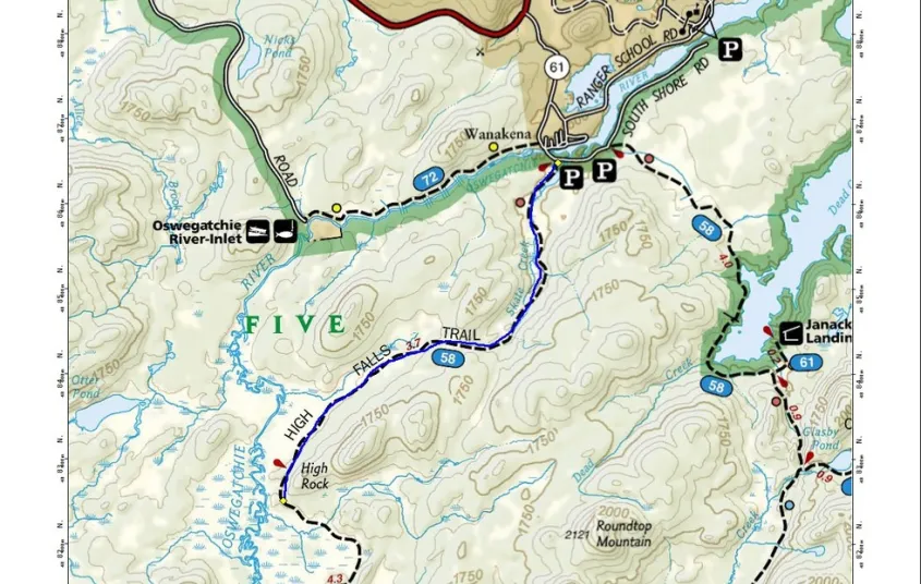
Hiking to High Rock
From the trailhead you will be on a very mellow hike along an old railroad grade, following red trail markers and blue CL50 trail markers. You cross over Skate Creek a couple times, and in some instances it can be very wet. Soon, a wide tributary of the Oswegatchie River comes into view on your right.
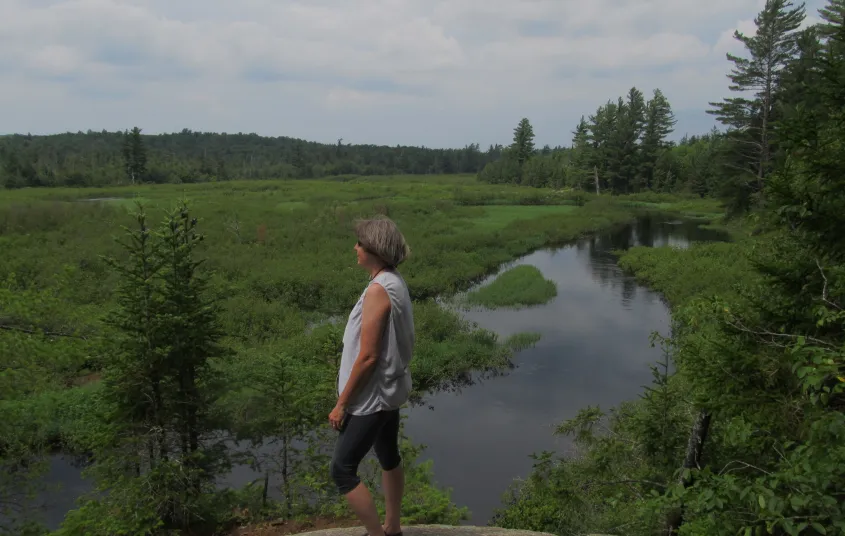
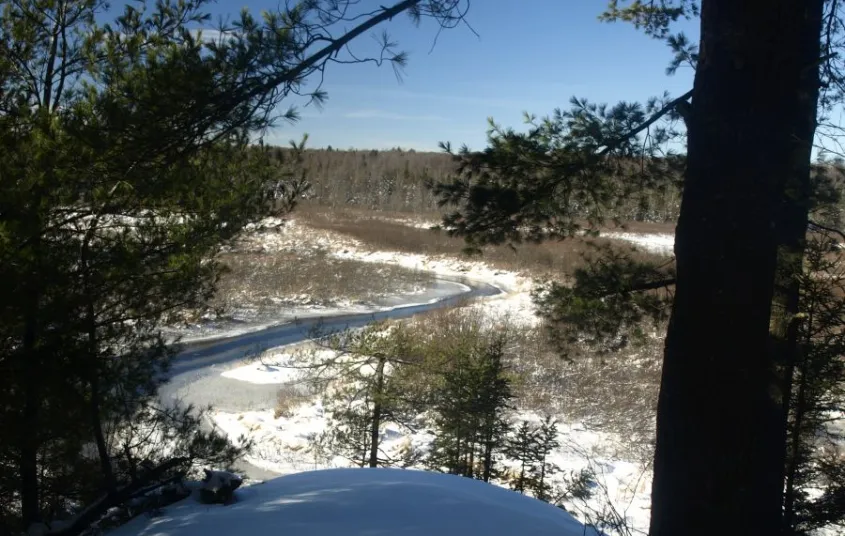
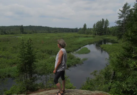
The flat trail continues and eventually you will come to an area where you can see the Oswegatchie River off in the distance through the trees. High Rock comes soon after with an outstanding overlook above the river. Look for the sign at the junction, which is for the 0.1 mile spur trail to High Rock. There are ample designated primitive campsites at this location.
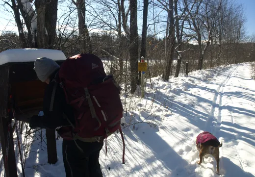
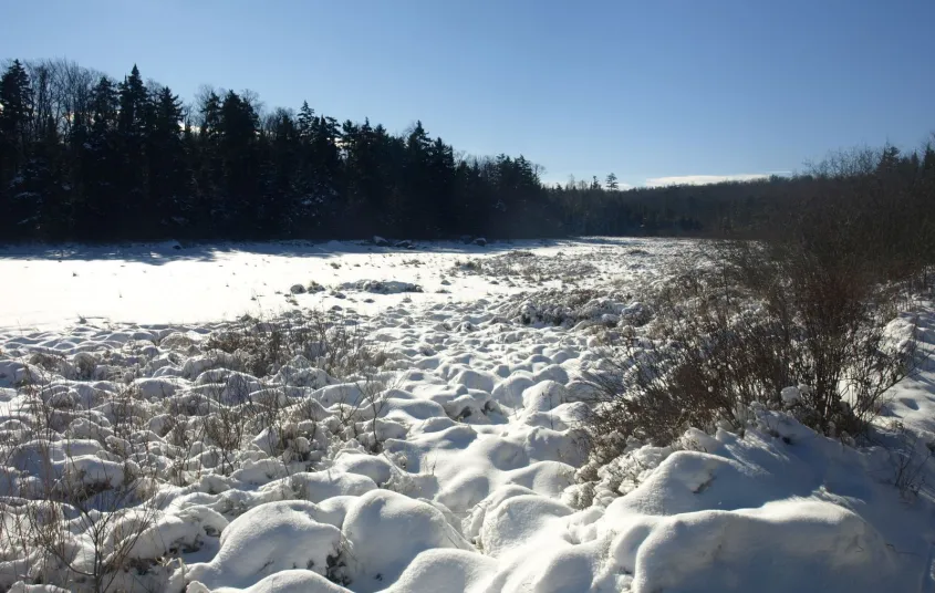
High Rock in the winter
This trail is accessible in the winter, and with the relatively flat grade for a majority of the hike, can be a decent option for those who have some experience cross-country skiing in the backcountry and want to try a higher-mileage trip. While flat, it is long and brings you deep into the backcountry, where you will likely be alone in the winter. As such, be prepared for all winter conditions. Bring layers, ample food and water, skis or snowshoes, and all other winter essentials.
Discover more trails
Looking to find some more trails to hike? With endless mountains, lakes, and waterfalls to visit in the Adirondacks, there are always more trails to discover!
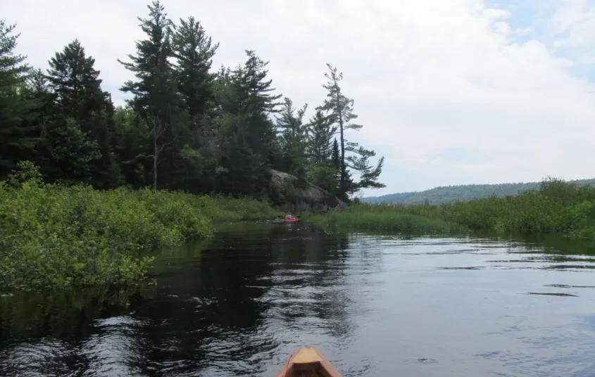
Paddling to High Rock
Paddling the Oswegatchie River is a classic Adirondack trip, and the paddle to High Rock can give you a taste of what a longer trip on this river could be like. It is a 3.3 mile paddle along the winding Oswegatchie River to the base of High Rock.
How to get there
From the intersection of Route 3 and Route 30 in the Village of Tupper Lake follow Route 3 toward Cranberry Lake. Follow Route 3 for 33.4 miles to CR61 (Wanakena Road) on the left. Follow here and stay straight on the main road to South Shore Road. Follow South Shore Road for around 0.25 miles to the trailhead parking on the right. You will have to walk back up the road for a couple hundred feet to the road on the left and walk this to its end, which is about 0.1 miles.
To paddle to High Rock: From the intersection of Route 3 and Route 30 in the Village of Tupper Lake follow Route 3 toward Cranberry Lake. Follow Route 3 for 36.4 miles to Inlet Road on the left, 3 miles past where you turn left to get to the hiking parking lot. Follow Inlet Road for 3 miles to the put-in on the Oswegatchie River.


Packages and Promotions
recurring
Valid
Valid Apr. 22 - Jun. 24
weekly on Saturday until April 27, 2027
Saint Giuseppe’s Weekly Chicken Special
Little Italy
Little Italy
Make Saturdays delicious with a beloved local tradition at Saint Giuseppe's Italian Cuisine.
promotion
1
week
SA
SA
range
Valid Nov. 30 - Jan. 27
Valid Nov. 19 - Jan. 27
Tupper Motel December / January Room Special
Escape to Tupper Lake This Winter!
Cozy Rooms, Unbeatable Rates at the Tupper Motel
Looking for a winter getaway that combines co
package
range
Valid Jan. 30 - Jan. 31
Valid Jan. 22 - Feb. 1
Raquette River Brewing 2 for 1 Boozy Hot Cocoa & Coffee
Raquette River Brewing
Raquette River Brewing
Warm up all weekend at Raquette River Brewing with 2-for-1 boozy hot cocoas
promotion
recurring
Valid
Valid May. 3 - May. 20
weekly on Sunday, Monday, Tuesday, Wednesday and Thursday until May 21, 2026
Happy Hour at Raquette River Brewing
Raquette River Brewing
Raquette River Brewing
promotion
1
week
SU,MO,TU,WE,TH
SU
range
Valid Aug. 7 - Aug. 14
Valid Aug. 7 - Aug. 14
Spruce & Hemlock: End of Season Clothing Sale
Spruce & Hemlock
Spruce & Hemlock
Join us for our End of Summer Sale with prices starting at just $10.00!
promotion
recurring
Valid
Valid Jul. 22 - Aug. 30
weekly on Monday, Tuesday, Wednesday, Thursday and Friday until August 30, 2025
Caribbean Kitchen Takeout
Faust Motel
Faust Motel
Caribbean Kitchen Pop-Up Takeout Returns
We’re excited to announce the retu
promotion
1
week
MO,TU,WE,TH,FR
MO
range
Valid Mar. 31 - Oct. 30
Valid Apr. 14 - Oct. 30
Fish & Stay
Voco Saranac Lake
Voco Saranac Lake
Enjoy a 2-hour fishing session on Lake Flower for two, guided by expert anglers.
package
Activities and Attractions
recurring
Valid
Valid Dec. 19 - Apr. 2
weekly on Thursday until April 3, 2026
Buns & Brews Special
P-2's Irish Pub
P-2's Irish Pub
Every Friday, P-2's Irish Pub on Main Street in Tupper Lake offers our delicious Buns & Brew Special.
promotion
1
week
TH
TH
range
Valid Mar. 31 - Mar. 31
Valid Mar. 31 - Mar. 31
The Wild Center Family Getaway at Voco
The Wild Center
The Wild Center
Enjoy 2 adult and 1 child admission tickets to The Wild Center, where nature meets discovery.
package
Activities and Attractions
range
Valid Jun. 30 - Jun. 30
Valid Jun. 30 - Jun. 30
Tri-State Resident discount at Trailhead
Residents of New York, New Jersey, and Connecticut are invited to enjoy savings of up to 15% on your next Adiron
package
Local Deals
range
Valid Jul. 3 - Aug. 30
Valid Jul. 1 - Aug. 30
Classic Films, Summer Vibes – Only $5
Adirondack State Theater
Adirondack State Theater
$5 classics. Cool theater. Daily at 4 PM. All summer long, the Adirondack State Theater brings timeless films to the big screen for just five bucks.
promotion
range
Valid Nov. 30
Valid Nov. 18 - Nov. 30
Raquette River Brewing - Cyber Monday
Raquette River Brewing
Raquette River Brewing
Cyber Monday Brews & Adirondack Views (From Your Couch!)
Get cozy this Cyber Monday and support local businesses from the comfort of y
promotion
range
Valid Sep. 5 - Sep. 24
Valid Sep. 7 - Sep. 23
Fall Foliage Special
Three nights for the price of TWO!
package
Mid-Week Discounts
range
Valid Mar. 31 - Oct. 30
Valid Apr. 14 - Oct. 30
Paddle & Stay
Voco Saranac Lake
Voco Saranac Lake
Escape to the serene beauty of the Adirondacks and immerse yourself in nature as you paddle the tranquil waters of Lake Flower in a kayak, canoe, or SUP
package
Activities and Attractions
range
Valid Nov. 27 - Nov. 29
Valid
Holiday Sale at Spruce & Hemlock!
Unwrap Holiday Cheer at Spruce & Hemlock!
Discover the perfect gifts for everyone on your list at Spruce & Hemlock's Holiday Sale!
promotion
range
Valid Jul. 31 - Aug. 2
Valid Mar. 31 - May. 30
BikeADK Loves Canada - Weekender
Canadian Residents can use the code “BikeADKLovesCanada" will receive 15% off their registration!
package
Other
range
Valid Apr. 30 - Sep. 29
Valid Apr. 30 - Sep. 29
Save on Multiple Days of Fishing!
Gone Fishing Guide Service and Boat Tours
Gone Fishing Guide Service and Boat Tours
Fish More & Save!
promotion
range
Valid
Valid Apr. 26 - May. 3
Mother’s Day Floral Pre-Orders at Cabin Fever Floral & Gifts
Cabin Fever Floral & Gifts
Cabin Fever Floral & Gifts
Mother’s Day Floral Pre-Orders at Cabin Fever Floral & Gifts
promotion
recurring
Valid
Valid Sep. 6 - Feb. 7
weekly on Sunday until February 8, 2026
Sunday GameDay Specials
Foul Line Sports Bar at Lakeview Lanes
Foul Line Sports Bar at Lakeview Lanes
Lakeview Lanes is Tupper Lake’s go-to destination for fun—whether you’re here for bowling, arcade games, or catchin
promotion
1
week
SU
SU
range
Valid Dec. 4 - Dec. 6
Valid Nov. 19 - Dec. 6
Holiday Stroll Cocktail Features
The Woodshed on Park
The Woodshed on Park
Get into the holiday spirit during the Holiday Stroll with seasonal cocktail features crafted just for the weekend.
package
Holidays, Special Events
range
Valid Jun. 30 - Sep. 29
Valid Jun. 30 - Sep. 29
weekly on Monday, Tuesday, Wednesday, Thursday, Friday, Saturday and Sunday until September 30, 2025
Timberjaxx Pass Loyalty Card
Timberjaxx Pass
Timberjaxx Pass
Get the Timberjaxx Loyalty Card and earn a free game after five rounds. Fun, treats, and no card to carry.
promotion
1
week
MO,TU,WE,TH,FR,SA,SU
MO
range
Valid Mar. 31 - Jan. 29
Valid Jan. 20 - Jan. 20
Pet Getaway
Your dog deserves an Adirondack getaway too. Book our pet friendly hotel near Lake Placid welcomes every member of your crew. Book our Pet Package and enjoy a dog friendly room with pet fees included.
package
Other
range
Valid Nov. 27 - Nov. 29
Valid Nov. 13 - Nov. 29
Three-Day Holiday Sale at Spruce & Hemlock
Spruce & Hemlock
Spruce & Hemlock
Holiday Sale at Spruce & Hemlock!
package
Holidays
range
Valid Mar. 31 - Oct. 30
Valid Apr. 14 - Oct. 30
Golf & Stay
Voco Saranac Lake
Voco Saranac Lake
Tee off at one of the Adirondacks' historic golf courses, surrounded by breathtaking mountain views.
package
Golf
recurring
Valid
Valid Jun. 15 - Oct. 16
weekly on Tuesday until October 21, 2025
Taco Tuesday at RRB
The Marketplace - Food Truck
The Marketplace - Food Truck, Raquette River Brewing
Free RRB Margarita with Your Marketplace Food Truck Tacos
Join The Marketplace Food Truck and Raquette River Brewing for the ultimate Taco
promotion
1
week
TU
TU
range
Valid Jun. 30 - Jun. 30
Valid Jul. 13 - Jun. 30
Book Now, Adventure Later with Trailhead
Book two or more consecutive nights 45+ days in advance and receive up to 20% off, with the flexibility to adjus
package
Early Bird Discounts
range
Valid Jun. 30 - Jun. 30
Valid Jun. 30 - Jun. 30
Stay More, Save More with Trailhead
Trailhead by Weekender
Trailhead by Weekender
package
Mid-Week Discounts
range
Valid Nov. 28
Valid Nov. 18 - Nov. 28
Raquette River Brewing - Small Business Saturday
Raquette River Brewing
Raquette River Brewing
Celebrate Small Business Saturday with Raquette River Brewing!
Skip the big box stores and connect with the heart of Tupper Lake this Smal
promotion
recurring
Valid
Valid Dec. 18 - Feb. 27
weekly on Wednesday until February 28, 2026
Wine Down Wednesday
P-2's Irish Pub
P-2's Irish Pub
Unwind midweek with 2-for-1 house wines every Wednesday during happy hour from 4-6 p.m. at P-2’s Irish Pub on Main Street in Tupper Lake.
promotion
1
week
WE
WE
range
Valid Nov. 28
Valid Nov. 25 - Nov. 28
Small Business Saturday at Ray's Discount Liquor
10% off on these specific liquor and wine.
Berlinger Founders Cab 1.5L and 75
All Boda Box 3 Liter
Machio Prosecco
package
Local Deals
range
Valid Nov. 27 - Nov. 28
Valid Nov. 24 - Nov. 28
Small Business Saturday
The Adirondack Store & Gallery
The Adirondack Store & Gallery
Adirondack Store and Gallery will be starting the Christmas shopping season off on Black Friday and continue through Small Business Saturday.
promotion
range
Valid Jul. 13 - Jul. 13
Valid Jul. 13 - Jul. 13
3rd Night Free at Trailhead
Book two consecutive nights at our regular Best Available Rate and get your 3rd night on us. Staying longer than three nights? 3rd Night Free! is available for EVERY 3rd night.
package
Mid-Week Discounts
range
Valid May. 11 - Aug. 30
Valid May. 11 - Aug. 30
Tupper Lake Motel 10% off
The Tupper Lake Motel
The Tupper Lake Motel
<meta charset='utf-8'>Complete the Tupper Lake Triad and enjoy 10% off your stay!
package
Other
recurring
Valid Apr. 29
Valid Apr. 21 - Apr. 29
weekly on Thursday until April 30, 2026
The Clubhouse Presents: Jamaican Night
The Clubhouse at TLGC
The Clubhouse at TLGC
Thursday, April 30th | 5:00 PM – 8:00 PM (or until sold out)
The Clubhouse in Tupper Lake is turning up the flavor with a special Jamaican
promotion
1
week
TH
TH
recurring
Valid
Valid Jun. 15 - Oct. 15
weekly on Wednesday until October 16, 2025
Wing Wednesdays: Full Flavor, Half Price!
The Clubhouse at TLGC
The Clubhouse at TLGC
Dig in and save big! Join us every Wednesday at The Clubhouse at Tupper Lake Golf Club for Wing Night Wednesdays, featuring 50% off chicken wings from 4:00 to 8:30 PM.
promotion
1
week
WE
WE
range
Valid Apr. 30 - Sep. 29
Valid Apr. 30 - Sep. 29
Discounts on your Fishing Trip for Military, Veterans & First Responders!
Gone Fishing Guide Service and Boat Tours
Gone Fishing Guide Service and Boat Tours
Captain Tommy appreciates your service and offers discounts to members of the Military, to Veterans and to First Responders.
promotion
recurring
Valid
Valid Sep. 26 - Oct. 28
weekly on Wednesday until October 29, 2025
Witchy Wednesdays Cocktail Features
The Woodshed on Park
The Woodshed on Park
Witchy Wednesdays—a month-long celebration of spooky season with enchanting cocktails crafted to thrill your taste buds.
promotion
1
week
WE
WE
range
Valid Jun. 7 - Aug. 30
Valid Jun. 7 - Aug. 30
Campers Get One Free Ticket!
Adirondack Scenic Railroad Train Rides
Adirondack Scenic Railroad Train Rides
Make your Adirondack camping getaway even more memorable!
promotion
range
Valid Jan. 20 - Jan. 20
Valid Jan. 20 - Dec. 31
Stay and Dine
Voco Saranac Lake
Voco Saranac Lake
Receive a 50 dollar credit per stay to use in our Lakeside Drift. Enjoy an exceptional dining experience with unparalleled views great food and craft beers in a friendly and relaxed environment.
package
range
Valid Nov. 27 - Nov. 28
Valid
Small Business Saturday
Tupper Arts
Tupper Arts
Black Friday and Small Business Saturday are headed to Tupper Arts on November 28 and November 29, 2025.
promotion
recurring
Valid
Valid Nov. 25 - May. 28
weekly on Tuesday until November 25, 2026
PorkBusters BBQ Taco Tuesdays!
Pork Busters - Food Truck
Pork Busters - Food Truck, Raquette River Brewing
Who doesn’t love Taco Tuesday?
promotion
1
week
TU
TU
recurring
Valid
Valid Jun. 15 - Oct. 15
weekly on Friday until October 17, 2025
$20 Fish Fry Friday
The Clubhouse at TLGC
The Clubhouse at TLGC
Get Hooked on Fish Fry Friday at The Clubhouse
Join us every Friday at The Clubhouse at TLGC for a delicious Fish Fry Friday tradition.
promotion
1
week
FR
FR
range
Valid Apr. 30 - Sep. 29
Valid Apr. 30 - Sep. 29
Kids Fish Free!
Gone Fishing Guide Service and Boat Tours
Gone Fishing Guide Service and Boat Tours
Kids 12& under fish free
promotion
range
Valid Nov. 27
Valid Nov. 18 - Nov. 27
Raquette River Brewing - Black Friday!
Raquette River Brewing
Raquette River Brewing
Score Big on Black Friday at Raquette River Brewing!
Looking for the perfect Adirondack souvenir or a gift for the craft beer lover in you
promotion
range
Valid Sep. 26
Valid Sep. 24 - Sep. 26
Free Pool All Day at P-2's Irish Pub
P-2's Irish Pub
P-2's Irish Pub
Free Pool at P-2's Irish Pub
promotion
recurring
Valid
Valid Jun. 13 - Oct. 15
weekly on Monday until October 14, 2025
Mexican Mondays
The Clubhouse at TLGC
The Clubhouse at TLGC
Head to The Clubhouse for bold flavors, rotating Mexican dishes, and $6 margaritas every Monday.
promotion
1
week
MO
MO
range
Valid Nov. 13
Valid
10 Year Anniversary at Spruce & Hemlock
Spruce & Hemlock
Spruce & Hemlock
Our 10 year Anniversary is on November 15th!
package
range
Valid Nov. 28
Valid Nov. 19 - Nov. 28
Small Business Saturday at Cabin Fever Floral
Cabin Fever Floral & Gifts
Cabin Fever Floral & Gifts
Cabin Fever is dicounting everything in the store 20%, sample our ADK Chocolates and enter to win a Christmas arrangement.
promotion
range
Valid Mar. 31 - Oct. 30
Valid Apr. 14 - Oct. 30
Bike & Stay
Voco Saranac Lake
Voco Saranac Lake
Explore the beauty of Saranac Lake and the newly developed Adirondack Rail Trail.
package
Activities and Attractions
range
Valid Nov. 25
Valid Nov. 24 - Nov. 26
Half Price Bowling & Shoes
Lakeview Lanes
Lakeview Lanes
Thanksgiving Eve Special at Lakeview Lanes
Kick off the holiday weekend wit
promotion
recurring
Valid
Valid Jun. 15 - Aug. 30
weekly on Friday until August 31, 2025
2 for 1 Happy Hour Cosmos and Friday Fish Fry
P-2's Irish Pub
P-2's Irish Pub
Start your weekend right with 2-for-1 Cosmopolitans for just $8 every Friday at P-2’s Irish Pub—plus don’t miss our Friday Fish Fry!
promotion
1
week
FR
FR
recurring
Valid
Valid Dec. 8 - May. 27
weekly on Thursday until July 30, 2026
Thursday Meal Deal
Raquette River Brewing
Raquette River Brewing, Fusion Pizza - Food Truck, Pork Busters - Food Truck
Thursday Deal at Raquette River Brewing! Every Thursday, head to Raquette River Brewing for a deal you won't want to miss. Spend $14 at LJ Food Truck and/or Fusion Street and receive a FREE drink token for your next round at the brewery. This special...
promotion
1
week
TH
TH
Discover More
Totally Tupper Lake
High water to High Rock!
Where is the Oswegatchie? When you look at the Adirondack Paddler's Map, the Oswegatchie River seems to be everywhere -- that is because it's 137 miles long! Its mouth is at the St. Lawrence River and it has two main branches, Middle and West, and...
Totally Tupper Lake
High Rock
It's been an odd winter so far with the warm weather and unpredictable snowfall. However, depending on where you go, the snowfall could be adequate enough to ski on. This was the case in the Five Ponds Wilderness Area, just prior to the recent warm...