17 miles: Cranberry Lake Wild Forest
The Five Ponds Wilderness Calls
My good friend Jamie and I have been hiking the Cranberry Lake 50 in short day-trip excursions and doing a complete inventory of the area for a 2016 launch of the Cranberry Lake 50 Pocket Planner, a user’s guide to the hiking trails there. We had been out collecting information two times prior, and the Five Ponds Wilderness trip would cover a different section of the trail. There's more to come on those adventures a bit later. After this we figure we have two more days of hiking before winter settles in.
Jamie and I got an early start on the day. We spotted one car at the Cat Mountain trailhead off South Shore Road in Wanakena and started our hike a half mile away at the High Rock trailhead. The High Rock trailhead is part of the Cranberry 50 and is often used as a hub for people starting the trail, a rightfully excellent spot if I may say so myself.

We pushed along the trail as it follows the old railroad grade created by the Rich Lumber Company many decades ago. The railroad must have been a scenic one, but it was not used as a tourist transport. The railroad grade led us through a flat portion of a very swampy area lined by Skate Creek. The beavers are very active in this area and it seems that controlling their architectural habits is a full-time job. It seems as soon as their beaver dam is removed or blown out it is rebuilt with additional ferocity. This dam is trailside and quickly floods the path, leaving hikers with one option — to get wet. It is usually important to bring some form of water shoes for certain sections of this loop and the Cranberry 50, but I wasn’t thinking that morning and mine remained at home. The flooding was there, but in my opinion it wasn't terrible. There were tufts of grass and slightly raised land masses to get us most of the way through, but a quick slip and my foot was submerged, filling my hiking boot like a bucket. The day was warm — warm enough not to cause concern for my safety and comfort — so we continued to press on. My foot would be dry enough soon, as long as I could remain topside.

Leading up to High Rock
We were out of the wet area which measured a few hundred feet and soon onto dry land, where we continued on at a decent clip. Soon we passed by the old Leary Trail, which was once obliterated by the 1995 micro-burst and left closed and unmaintained by the state Department of Environmental Conservation. In recent years its location was found again and opened up. Marked with blue trail disks, it still remains unmaintained by the DEC, but a private entity has since taken command. The Leary Trail offers hikers a direct route to the Five Ponds Trail and a reduced distance to High Falls, cutting about 2 miles out of the one-way trip back to the scenic destinations.

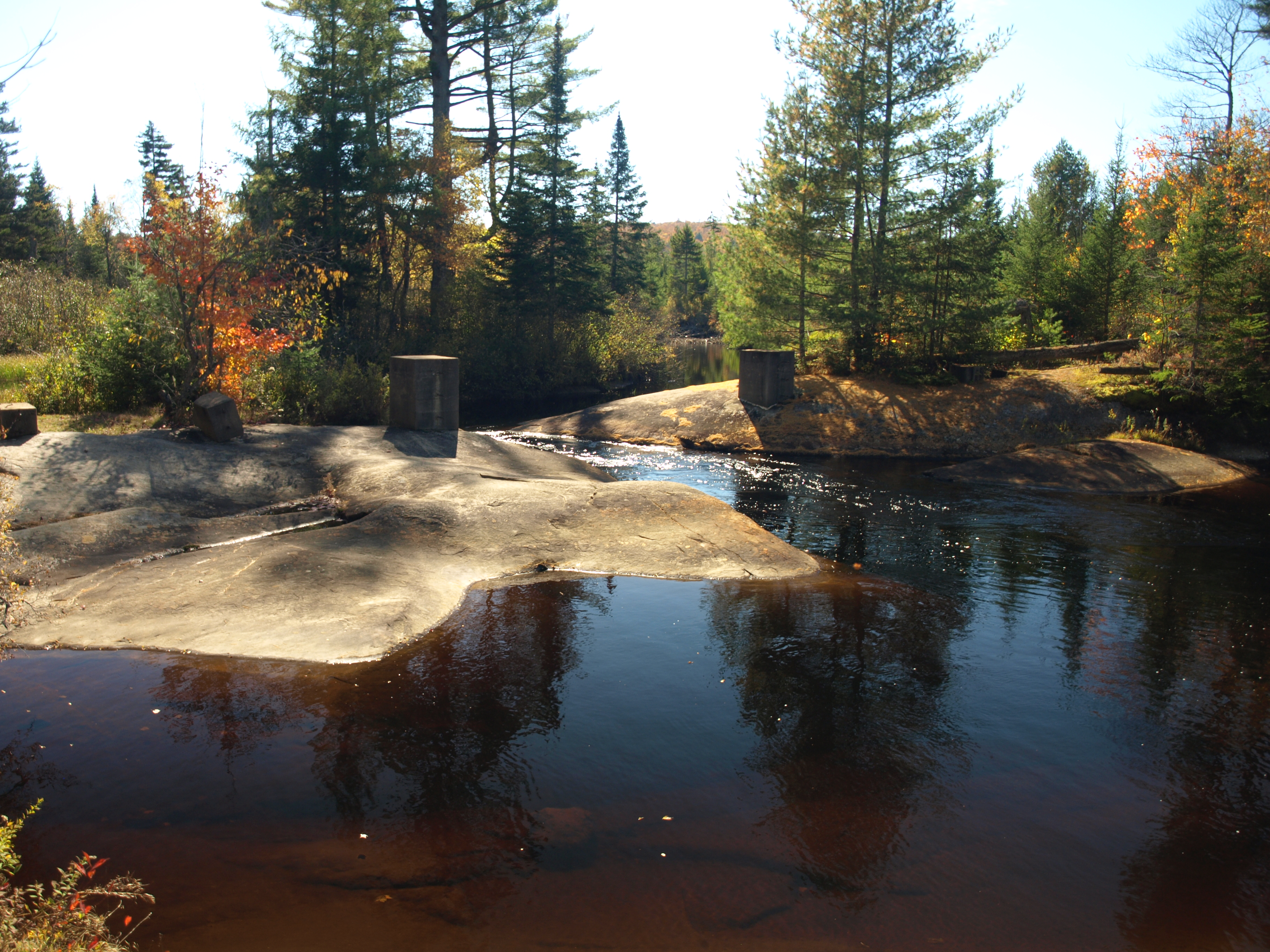
We didn’t use the Leary Trail as we needed to inventory the Cranberry 50 trail, and the Leary Trail would not allow us to visit High Rock and other camping destinations in the area. Pressing on, we quickly arrived at the 0.1 mile spur trail to the High Rock camps. We ran down the short spur trail to not only take note of the campsites located there but to soak in the outstanding fall vistas out over the Oswegatchie River. Quick snacks were in order before we moved on along the loop. Soon we were at the rock slabs of what we called Roundtop Brook. Standing atop an old concrete bridge, it was hard to believe it was strong enough for a railroad bridge, but then again back in the 1800s and early 1900s there weren’t as many checks and balances for bridge construction.
Our next anticipated intersection was the trail back to Five Ponds and Sand Pond, but that was some distance away. The trail was very flat but we knew wet areas could persist along this section. We were prepared for just about anything, aside from my water shoes being dry at home next to the back door. Sure, the trail was close to a wetland — we had to cross a few beaver dams — but wetness was not a feature we encountered. The fall was a dry one, so we weren’t all that surprised. We checked out a few campsites along the way to make note of their condition and amenities, and swiftly moved on.
Off to High Falls
At the trail intersection for Five Ponds, an interesting historical artifact of logging past welcomed us in its oddity. There was a spruce tree growing through the remains of a trailer, back end of a truck, or something of the like. It was quite some distance down the Five Ponds Trail to the crossing of the Oswegatchie River and much farther to Five Ponds, so we opted not to adventure that way in respect of time restraints. Just past the trailhead we noticed the opposite side of the Leary Trail, clearly marked and brushed out. We would have to come back another time to explore a bit deeper.

Next we came to the High Falls Trail, which was less than 1 mile away. Considering reports we received from hikers over the summer, we expected very wet conditions for a while as it passed through The Plains, but we didn’t have any of that. It was dry as a bone and had no flooding from beaver activity, and we were happy to see this. The High Falls spur trail comes quickly and it was only 0.4 miles to the falls from this point, so we had to go. The spur is a flat section of trail with only a slight descent to the river. Along the way we passed below a small beaver pond and passed by an old tractor or piece of logging equipment, a unique spectacle along the trail that people often wonder about. The piece of equipment looks to be an old log winch system with tracks. Now seized up with time, it has found its final resting place, doomed to be photographed and climbed upon by thousands of weary travelers.


High Falls is the most scenic portion of this trail, and is considered a gem by all who visit. Old concrete blocks remain at the top of the falls, which once possibly stabilized a suspension bridge to the other side of the river. An old lodge once resided here, and the suspension bridge was possibly a key note for patrons, hunters, and tourists alike.
Lunch break came and went and we hightailed it back to the intersection. We moved on through The Plains and climbed up and over one of the most elevated portions of the trail, an unnamed little knob. On our left we noted another small rocky knob, not named either but interesting. I was intrigued. I must climb. I didn’t go to the knob itself but to a long rocky spine to the right of it, where I took in 180 degree views out to Three Mile Mountain, back to Roundtop Mountain, and out over the colorful forest of Glasby Creek.
Next we looked forward to the Cat Mountain Trail intersection, where we would leave the Cranberry 50 and finish off the High Falls loop on a trail we were both more than familiar with. Three Mile Mountain loomed over us in its colorful autumn drape as we came to the dreaded log crossing. This is a nearly 40 foot log crossing suspended above a pool of unknown depth. It might not have a bottom. Bouncing slightly under us, we went from the wide end of the log to the narrow end. The wide end was flattened for better footing, but as we approached the knob-infested narrow side it became more rounded and much less stable. Someone had run a shoestring along the side for a balance aid which, while giving no real support, was a nice mental balance for the spanning. I couldn’t imagine how a full pack would be to carry over this.

We quickly came to the intersection for Cat Mountain following a slight climb to a height of land. The Janacks Landing Trail is only about a mile away and on an easy course, and with only one beaver flow to contend with we were there in a flash. We decided not go to Janacks Landing, as we had been there many times before and honestly just wanted to be back at the car. We slipped our gears into overdrive and moved along the remaining portion of the trail without falter. Passing by the camps at Dead Creek Flow and the dozen or so college students residing there, we talked about that one more section of flooded trail before us. By the time we reached that area we were very close to the trailhead and wet feet didn’t scare us — we would be dry in a flash. It was flooded, but again not as bad as we had been warned about. Maybe our sense of flooding is not as raised as some. With the help of my trekking poles and a couple of solid leaps of faith we were on the other side of the flood plain and out to the trailhead.
The day was a solid success with nearly 17 miles under our belts and a large portion of the Cranberry 50 inventoried, and we were quite satisfied with what we accomplished.
Hungry after your hike? Swing by Tupper Lake for some sit-down dining or a quick bite before you hit the road! Don't feel like driving? Check out Tupper Lake's lodging options.
