


44.110173, -74.670902
Note: Access to Lows Lower Dam will be closed for the 2024 season. For further information, and the latest from the DEC on Lows Lower Dam access, check the Bog River Complex page.
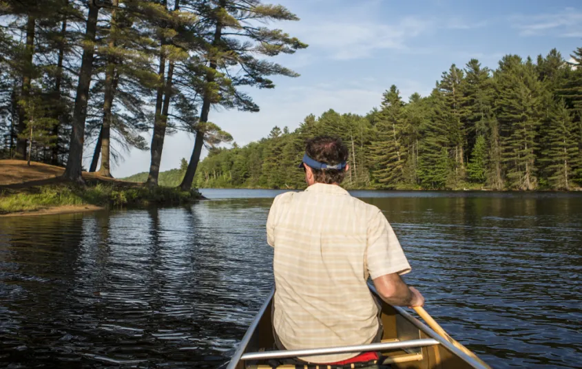
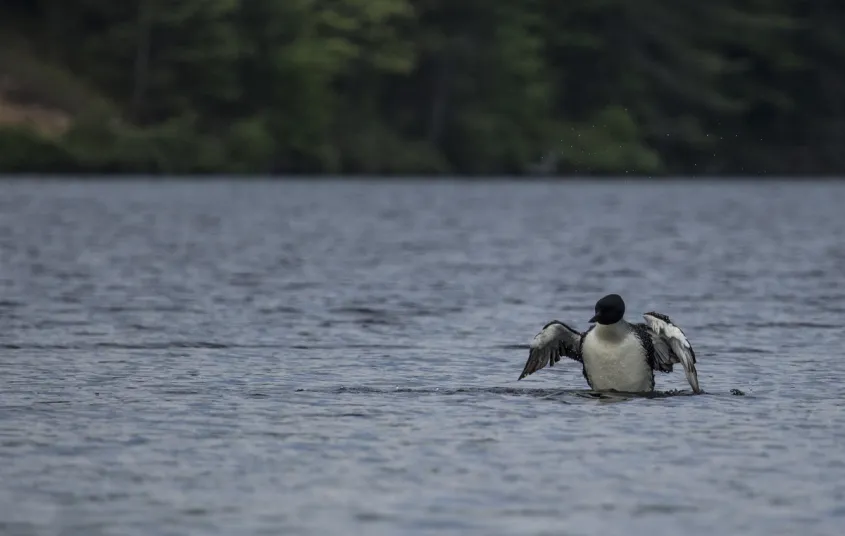
The remote and serene backcountry paddle into Lows Lake is the perfect spot for a multi-day paddling trip. It's a motorboat-free location with 39 primitive campsites, and it's also one of the largest nesting areas for loons in the state.
Getting there
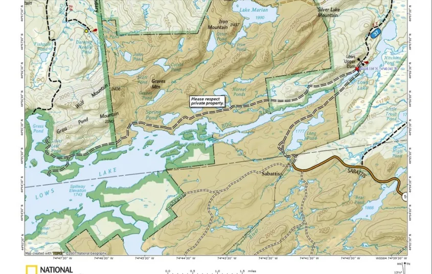
From the intersection of Route 30 and Route 3 in Tupper Lake, follow Route 30 toward Long Lake. Turn right on Route 421 and follow it for about 6 miles to the access road for Lows Lower Dam. Please note this is a very small parking lot for the heavy use it gets.
Paddling
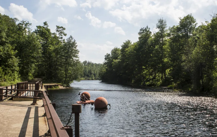
Get to Lows Lake by following the Bog River from Lows Lower Dam to Hitchins Pond. Cross the pond and take out along the rocky shore near the base of Lows Upper Dam. The carry up and over the dam is aided by a well-maintained footpath and forest road. Continue following the Bog River to Lows Lake, about 11 miles from the first dam.
Plan on spending more than a day exploring this massive and scenic lake. Loon calls fill the air, the wetland boasts colorful birds and plants, and splendid views of rugged mountains surround this wilderness area. Lows Lake is possibly one of the most talked about and secluded lakes in the Adirondacks.
Type of launch: There is a carry of about 200 feet and a dirt launch.
Type of water: A gentle current along a river to a backcountry pond.


Packages and Promotions
range
Valid Nov. 25
Valid Nov. 24 - Nov. 26
Half Price Bowling & Shoes
Lakeview Lanes
Lakeview Lanes
Thanksgiving Eve Special at Lakeview Lanes
Kick off the holiday weekend wit
promotion
range
Valid
Valid Apr. 26 - May. 3
Mother’s Day Floral Pre-Orders at Cabin Fever Floral & Gifts
Cabin Fever Floral & Gifts
Cabin Fever Floral & Gifts
Mother’s Day Floral Pre-Orders at Cabin Fever Floral & Gifts
promotion
recurring
Valid
Valid Jul. 22 - Aug. 30
weekly on Monday, Tuesday, Wednesday, Thursday and Friday until August 30, 2025
Caribbean Kitchen Takeout
Faust Motel
Faust Motel
Caribbean Kitchen Pop-Up Takeout Returns
We’re excited to announce the retu
promotion
1
week
MO,TU,WE,TH,FR
MO
range
Valid Nov. 27
Valid Nov. 18 - Nov. 27
Raquette River Brewing - Black Friday!
Raquette River Brewing
Raquette River Brewing
Score Big on Black Friday at Raquette River Brewing!
Looking for the perfect Adirondack souvenir or a gift for the craft beer lover in you
promotion
range
Valid Nov. 27 - Nov. 28
Valid Nov. 24 - Nov. 28
Small Business Saturday
The Adirondack Store & Gallery
The Adirondack Store & Gallery
Adirondack Store and Gallery will be starting the Christmas shopping season off on Black Friday and continue through Small Business Saturday.
promotion
range
Valid Sep. 26
Valid Sep. 24 - Sep. 26
Free Pool All Day at P-2's Irish Pub
P-2's Irish Pub
P-2's Irish Pub
Free Pool at P-2's Irish Pub
promotion
range
Valid Apr. 30 - Sep. 29
Valid Apr. 30 - Sep. 29
Kids Fish Free!
Gone Fishing Guide Service and Boat Tours
Gone Fishing Guide Service and Boat Tours
Kids 12& under fish free
promotion
range
Valid Nov. 30
Valid Nov. 18 - Nov. 30
Raquette River Brewing - Cyber Monday
Raquette River Brewing
Raquette River Brewing
Cyber Monday Brews & Adirondack Views (From Your Couch!)
Get cozy this Cyber Monday and support local businesses from the comfort of y
promotion
recurring
Valid
Valid Sep. 26 - Oct. 28
weekly on Wednesday until October 29, 2025
Witchy Wednesdays Cocktail Features
The Woodshed on Park
The Woodshed on Park
Witchy Wednesdays—a month-long celebration of spooky season with enchanting cocktails crafted to thrill your taste buds.
promotion
1
week
WE
WE
range
Valid Jun. 30 - Jun. 30
Valid Jun. 30 - Jun. 30
Stay More, Save More with Trailhead
Trailhead by Weekender
Trailhead by Weekender
package
Mid-Week Discounts
recurring
Valid
Valid Nov. 25 - May. 28
weekly on Tuesday until November 25, 2026
PorkBusters BBQ Taco Tuesdays!
Pork Busters - Food Truck
Pork Busters - Food Truck, Raquette River Brewing
Who doesn’t love Taco Tuesday?
promotion
1
week
TU
TU
recurring
Valid
Valid May. 3 - May. 20
weekly on Sunday, Monday, Tuesday, Wednesday and Thursday until May 21, 2026
Happy Hour at Raquette River Brewing
Raquette River Brewing
Raquette River Brewing
promotion
1
week
SU,MO,TU,WE,TH
SU
recurring
Valid
Valid Jun. 15 - Oct. 16
weekly on Tuesday until October 21, 2025
Taco Tuesday at RRB
The Marketplace - Food Truck
The Marketplace - Food Truck, Raquette River Brewing
Free RRB Margarita with Your Marketplace Food Truck Tacos
Join The Marketplace Food Truck and Raquette River Brewing for the ultimate Taco
promotion
1
week
TU
TU
range
Valid Mar. 31 - Oct. 30
Valid Apr. 14 - Oct. 30
Paddle & Stay
Voco Saranac Lake
Voco Saranac Lake
Escape to the serene beauty of the Adirondacks and immerse yourself in nature as you paddle the tranquil waters of Lake Flower in a kayak, canoe, or SUP
package
Activities and Attractions
range
Valid Jun. 7 - Aug. 30
Valid Jun. 7 - Aug. 30
Campers Get One Free Ticket!
Adirondack Scenic Railroad Train Rides
Adirondack Scenic Railroad Train Rides
Make your Adirondack camping getaway even more memorable!
promotion
range
Valid Jan. 30 - Jan. 31
Valid Jan. 22 - Feb. 1
Raquette River Brewing 2 for 1 Boozy Hot Cocoa & Coffee
Raquette River Brewing
Raquette River Brewing
Warm up all weekend at Raquette River Brewing with 2-for-1 boozy hot cocoas
promotion
recurring
Valid Jun. 30 - Aug. 29
Valid Jun. 30 - Aug. 29
weekly on Tuesday, Wednesday, Thursday, Friday, Saturday and Sunday until August 30, 2026
Classic Films, Summer Vibes – Only $5
Adirondack State Theater
Adirondack State Theater
$5 classics. Cool theater. Daily at 4 PM. All summer long, the Adirondack State Theater brings timeless films to the big screen for just five bucks.
promotion
1
week
TU,WE,TH,FR,SA,SU
TU
range
Valid Jul. 13 - Jul. 13
Valid Jul. 13 - Jul. 13
3rd Night Free at Trailhead
Book two consecutive nights at our regular Best Available Rate and get your 3rd night on us. Staying longer than three nights? 3rd Night Free! is available for EVERY 3rd night.
package
Mid-Week Discounts
range
Valid May. 11 - Aug. 30
Valid May. 11 - Aug. 30
Tupper Lake Motel 10% off
The Tupper Lake Motel
The Tupper Lake Motel
<meta charset='utf-8'>Complete the Tupper Lake Triad and enjoy 10% off your stay!
package
Other
range
Valid Nov. 27 - Nov. 29
Valid Nov. 13 - Nov. 29
Three-Day Holiday Sale at Spruce & Hemlock
Spruce & Hemlock
Spruce & Hemlock
Holiday Sale at Spruce & Hemlock!
package
Holidays
range
Valid Dec. 4 - Dec. 6
Valid Nov. 19 - Dec. 6
Holiday Stroll Cocktail Features
The Woodshed on Park
The Woodshed on Park
Get into the holiday spirit during the Holiday Stroll with seasonal cocktail features crafted just for the weekend.
package
Holidays, Special Events
range
Valid Nov. 28
Valid Nov. 19 - Nov. 28
Small Business Saturday at Cabin Fever Floral
Cabin Fever Floral & Gifts
Cabin Fever Floral & Gifts
Cabin Fever is dicounting everything in the store 20%, sample our ADK Chocolates and enter to win a Christmas arrangement.
promotion
range
Valid Nov. 27 - Nov. 28
Valid
Small Business Saturday
Tupper Arts
Tupper Arts
Black Friday and Small Business Saturday are headed to Tupper Arts on November 28 and November 29, 2025.
promotion
range
Valid Nov. 28
Valid Nov. 18 - Nov. 28
Raquette River Brewing - Small Business Saturday
Raquette River Brewing
Raquette River Brewing
Celebrate Small Business Saturday with Raquette River Brewing!
Skip the big box stores and connect with the heart of Tupper Lake this Smal
promotion
range
Valid Jan. 20 - Jan. 20
Valid Jan. 20 - Dec. 31
Stay and Dine
Voco Saranac Lake
Voco Saranac Lake
Receive a 50 dollar credit per stay to use in our Lakeside Drift. Enjoy an exceptional dining experience with unparalleled views great food and craft beers in a friendly and relaxed environment.
package
recurring
Valid
Valid Sep. 6 - Feb. 7
weekly on Sunday until February 8, 2026
Sunday GameDay Specials
Foul Line Sports Bar at Lakeview Lanes
Foul Line Sports Bar at Lakeview Lanes
Lakeview Lanes is Tupper Lake’s go-to destination for fun—whether you’re here for bowling, arcade games, or catchin
promotion
1
week
SU
SU
range
Valid Sep. 5 - Sep. 24
Valid Sep. 7 - Sep. 23
Fall Foliage Special
Three nights for the price of TWO!
package
Mid-Week Discounts
recurring
Valid
Valid Jun. 15 - Oct. 15
weekly on Wednesday until October 16, 2025
Wing Wednesdays: Full Flavor, Half Price!
The Clubhouse at TLGC
The Clubhouse at TLGC
Dig in and save big! Join us every Wednesday at The Clubhouse at Tupper Lake Golf Club for Wing Night Wednesdays, featuring 50% off chicken wings from 4:00 to 8:30 PM.
promotion
1
week
WE
WE
recurring
Valid
Valid Jun. 13 - Oct. 15
weekly on Monday until October 14, 2025
Mexican Mondays
The Clubhouse at TLGC
The Clubhouse at TLGC
Head to The Clubhouse for bold flavors, rotating Mexican dishes, and $6 margaritas every Monday.
promotion
1
week
MO
MO
range
Valid Mar. 31 - Jan. 29
Valid Jan. 20 - Jan. 20
Pet Getaway
Your dog deserves an Adirondack getaway too. Book our pet friendly hotel near Lake Placid welcomes every member of your crew. Book our Pet Package and enjoy a dog friendly room with pet fees included.
package
Other
recurring
Valid Apr. 29
Valid Apr. 21 - Apr. 29
weekly on Thursday until April 30, 2026
The Clubhouse Presents: Jamaican Night
The Clubhouse at TLGC
The Clubhouse at TLGC
Thursday, April 30th | 5:00 PM – 8:00 PM (or until sold out)
The Clubhouse in Tupper Lake is turning up the flavor with a special Jamaican
promotion
1
week
TH
TH
range
Valid Nov. 30 - Jan. 27
Valid Nov. 19 - Jan. 27
Tupper Motel December / January Room Special
Escape to Tupper Lake This Winter!
Cozy Rooms, Unbeatable Rates at the Tupper Motel
Looking for a winter getaway that combines co
package
range
Valid Mar. 31 - Mar. 31
Valid Mar. 31 - Mar. 31
The Wild Center Family Getaway at Voco
The Wild Center
The Wild Center
Enjoy 2 adult and 1 child admission tickets to The Wild Center, where nature meets discovery.
package
Activities and Attractions
recurring
Valid
Valid Jun. 15 - Oct. 15
weekly on Friday until October 17, 2025
$20 Fish Fry Friday
The Clubhouse at TLGC
The Clubhouse at TLGC
Get Hooked on Fish Fry Friday at The Clubhouse
Join us every Friday at The Clubhouse at TLGC for a delicious Fish Fry Friday tradition.
promotion
1
week
FR
FR
range
Valid Apr. 30 - Sep. 29
Valid Apr. 30 - Sep. 29
Save on Multiple Days of Fishing!
Gone Fishing Guide Service and Boat Tours
Gone Fishing Guide Service and Boat Tours
Fish More & Save!
promotion
recurring
Valid
Valid Dec. 19 - Apr. 2
weekly on Thursday until April 3, 2026
Buns & Brews Special
P-2's Irish Pub
P-2's Irish Pub
Every Friday, P-2's Irish Pub on Main Street in Tupper Lake offers our delicious Buns & Brew Special.
promotion
1
week
TH
TH
range
Valid Nov. 27 - Nov. 29
Valid
Holiday Sale at Spruce & Hemlock!
Unwrap Holiday Cheer at Spruce & Hemlock!
Discover the perfect gifts for everyone on your list at Spruce & Hemlock's Holiday Sale!
promotion
range
Valid Mar. 31 - Oct. 30
Valid Apr. 14 - Oct. 30
Fish & Stay
Voco Saranac Lake
Voco Saranac Lake
Enjoy a 2-hour fishing session on Lake Flower for two, guided by expert anglers.
package
Activities and Attractions
range
Valid Nov. 28
Valid Nov. 25 - Nov. 28
Small Business Saturday at Ray's Discount Liquor
10% off on these specific liquor and wine.
Berlinger Founders Cab 1.5L and 75
All Boda Box 3 Liter
Machio Prosecco
package
Local Deals
range
Valid Jun. 30 - Jun. 30
Valid Jun. 30 - Jun. 30
Tri-State Resident discount at Trailhead
Residents of New York, New Jersey, and Connecticut are invited to enjoy savings of up to 15% on your next Adiron
package
Local Deals
range
Valid Nov. 13
Valid
10 Year Anniversary at Spruce & Hemlock
Spruce & Hemlock
Spruce & Hemlock
Our 10 year Anniversary is on November 15th!
package
range
Valid May. 31 - Oct. 14
Valid May. 31 - Oct. 14
weekly on Monday, Tuesday, Wednesday, Thursday, Friday, Saturday and Sunday until September 30, 2025
Timberjaxx Pass Loyalty Card
Timberjaxx Pass
Timberjaxx Pass
Get the Timberjaxx Loyalty Card and earn a free game after five rounds. Fun, treats, and no card to carry.
promotion
1
week
MO,TU,WE,TH,FR,SA,SU
MO
recurring
Valid
Valid Jun. 15 - Aug. 30
weekly on Friday until August 31, 2025
2 for 1 Happy Hour Cosmos and Friday Fish Fry
P-2's Irish Pub
P-2's Irish Pub
Start your weekend right with 2-for-1 Cosmopolitans for just $8 every Friday at P-2’s Irish Pub—plus don’t miss our Friday Fish Fry!
promotion
1
week
FR
FR
recurring
Valid
Valid Dec. 8 - May. 27
weekly on Thursday until July 30, 2026
Thursday Meal Deal
Raquette River Brewing
Raquette River Brewing, Fusion Pizza - Food Truck, Pork Busters - Food Truck
Thursday Deal at Raquette River Brewing! Every Thursday, head to Raquette River Brewing for a deal you won't want to miss. Spend $14 at LJ Food Truck and/or Fusion Street and receive a FREE drink token for your next round at the brewery. This special...
promotion
1
week
TH
TH
range
Valid Mar. 31 - Oct. 30
Valid Apr. 14 - Oct. 30
Bike & Stay
Voco Saranac Lake
Voco Saranac Lake
Explore the beauty of Saranac Lake and the newly developed Adirondack Rail Trail.
package
Activities and Attractions
range
Valid Apr. 30 - Sep. 29
Valid Apr. 30 - Sep. 29
Discounts on your Fishing Trip for Military, Veterans & First Responders!
Gone Fishing Guide Service and Boat Tours
Gone Fishing Guide Service and Boat Tours
Captain Tommy appreciates your service and offers discounts to members of the Military, to Veterans and to First Responders.
promotion
range
Valid Jun. 30 - Jun. 30
Valid Jul. 13 - Jun. 30
Book Now, Adventure Later with Trailhead
Book two or more consecutive nights 45+ days in advance and receive up to 20% off, with the flexibility to adjus
package
Early Bird Discounts
range
Valid Jul. 31 - Aug. 2
Valid Mar. 31 - May. 30
BikeADK Loves Canada - Weekender
Canadian Residents can use the code “BikeADKLovesCanada" will receive 15% off their registration!
package
Other
range
Valid Mar. 31 - Oct. 30
Valid Apr. 14 - Oct. 30
Golf & Stay
Voco Saranac Lake
Voco Saranac Lake
Tee off at one of the Adirondacks' historic golf courses, surrounded by breathtaking mountain views.
package
Golf
recurring
Valid
Valid Apr. 22 - Jun. 24
weekly on Saturday until April 27, 2027
Saint Giuseppe’s Weekly Chicken Special
Little Italy
Little Italy
Make Saturdays delicious with a beloved local tradition at Saint Giuseppe's Italian Cuisine.
promotion
1
week
SA
SA